


၏ ရွင္းလင္းခ်က္ Maps Measure
Simple app to measure distances and areas in Google Maps.
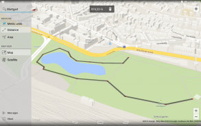
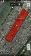
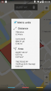
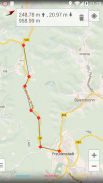
Just click on the map to add different points - Maps Measure will then calculate the distance, area or elevation* between those points.
This app does not calculate a route or something like that - it's not a navigation or route planning app.
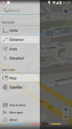
Swipe in from the left side to access more options, long-click on the trash icon to delete all set points.
Features:
• Measure distances, areas & elevations*
• Imperial & metric units
• Map, hybrid-satellite & terrain view
• No ads
• Minimum permissions & open source
• Holo-themed with support for translucent system decor on Android 4.4
*the elevations feature requires an in-app purchase (0.99 EUR, 1.49 USD)
Permissions:
INTERNET & ACCESS_NETWORK_STATE - showing the map and getting altitude data
WRITE_EXTERNAL_STORAGE - caching map data
ACCESS_COARSE_LOCATION & ACCESS_FINE_LOCATION - displaying your current location on the map
BILLING - upgrade to the pro-version through an in-app purchase
The app does not show any ads or collects any of your data.
The app is open source and listed on GitHub: https://github.com/j4velin/MapsMeasure
Icon provided by https://github.com/amirdesaingrafis
Google Maps တွင်အကွာအဝေးနှင့်ဒေသများတိုင်းတာရန်ရိုးရှင်းတဲ့ app ကို။
ရုံကွဲပြားခြားနားသောအချက်များကိုထည့်သွင်းဖို့မြေပုံပေါ်တွင်ကလစ်လုပ်ပါ - Maps ကို ထိုအချက်များကိုအကြား * အကွာအဝေး, ဧရိယာသို့မဟုတ်မြင့်တွက်ချက်ပါလိမ့်မယ်တိုင်းတာပါ။
ဒီ app တစ်ခုကိုကဲ့သို့သောလမ်းကြောင်းသို့မဟုတ်တစ်ခုခုတွက်ချက်မထားဘူး - ကအညွှန်းသို့မဟုတ်လမ်းကြောင်းစီမံကိန်းရေးဆွဲခြင်း app ကိုမဟုတ်ပါဘူး။
ပိုပြီးရွေးချယ်စရာဝင်ရောက်ဖို့လက်ဝဲဘက်ခြမ်းမှပွတ်ဆွဲ, ရှိသမျှအစုံအချက်များကိုပယ်ဖျက်ဖို့အမှိုက် icon ပေါ်တွင်အချိန်ကြာမြင့်စွာကိုကလစ်နှိပ်ပါ။
အင်္ဂါရပ်များ:
•တိုင်းအကွာအဝေး, ဒေသများ & မြင့်တက် *
•မှာ Imperial & မက်ထရစ်ယူနစ်
•မြေပုံ, ဟိုက်ဘရစ်-ဂြိုဟ်တု & မြေပြင်အနေအထားအမြင်
•အဘယ်သူမျှမကြော်ငြာတွေ
•အနိမ့်ခွင့်ပြုချက် & open source ဖြစ်ပြီး
•က Android 4.4 အပေါ်စသည့်စနစ်ပုံစံမျိုးများအတွက်ထောက်ခံမှုနှင့်အတူဟိုလို-အခြေတည်
* ဓါတ်လှေကား feature တစ်ခု In-app ကိုဝယ်ယူ (0.99 EUR, 1.49 အမေရိကန်ဒေါ်လာ) လိုအပ်ပါတယ်
ခွင့်ပြုချက်များ:
အင်တာနက် & ACCESS_NETWORK_STATE - မြေပုံဖေါ်ပြခြင်းနဲ့အမြင့်ဒေတာဆိုတော့
WRITE_EXTERNAL_STORAGE - မြေပုံဒေတာသိမ်းဆည်းထားသော
ACCESS_COARSE_LOCATION & ACCESS_FINE_LOCATION - မြေပုံပေါ်တွင်သင်၏လက်ရှိတည်နေရာကိုပြသ
ငွေတောင်းခံ - တစ်ဦး In-app ကိုဝယ်ယူမှတဆင့်လိုလားသူဗားရှင်း upgrade
ဒီ app ဆိုကြော်ငြာများသို့မဟုတ်သင့်ဒေတာတွေကိုမဆိုစုဆောင်းမထားဘူး။
ဒီ app ကိုဖွင့်အရင်းအမြစ်တစ်ခုဖြစ်ပြီး GitHub အပေါ်စာရင်းဝင်: https://github.com/j4velin/MapsMeasure
https://github.com/amirdesaingrafis ပေးအိုင်ကွန်
Maps Measure - ဗားရွင္း 1.5.1
(23-05-2023)

Maps Measure - APK သတင္းအခ်က္အလက္
APK ဗားရွင္း: 1.5.1package: de.j4velin.mapsmeasureက႑တူအက္ပ္မ်ား
သင္ႏွစ္သက္ႏိုင္သည္မ်ားမွာ...


